

Executive Overview
The autonomous vehicle landscape is undergoing a high-stakes, sharply contrasting evolution across the United States. Alphabet’s autonomous driving subsidiary, Waymo, has announced a massive expansion of its driverless taxi operations across Los Angeles, San Francisco, and Silicon Valley. In total, the company is adding more than 80 square miles to its existing geofenced operational footprints. This sweeping update increases Waymo’s overall coverage across the Golden State by roughly 50%, bringing its cumulative service territory to approximately 250 square miles.
This strategic scaling is not occurring in a vacuum. Waymo’s aggressive expansion comes less than a week before the tentative, much-anticipated commercial rollout of Tesla’s competing robotaxi service in Austin, Texas—a market where Waymo also maintains a presence. These concurrent developments highlight two fundamentally different philosophies in the race toward commercial autonomy: Waymo’s methodical, safety-validated, multi-year geofenced scaling versus Tesla’s aggressive, camera-based, rapid-deployment approach.
As regulatory bodies, industry analysts, and everyday commuters look on, the contrast between Waymo’s Level 4 commercial maturity and Tesla’s impending Level 2-to-4 pivot has never been starker. This report examines the mechanics of Waymo’s latest California expansion, the geographic nuances of its new service territories, the glaring absence of major international airport access, and the deep technical and strategic divides separating the two autonomous vehicle titans.
Detailed Chronology & Regional Breakdown
Waymo’s latest infrastructural growth has unfolded across a tightly coordinated multi-day rollout spanning mid-June 2025. By systematically mapping, testing, and progressively opening new corridors, the company continues to cement its status as the undisputed commercial leader in full-scale driverless public transportation.
San Francisco and the Peninsula Extension
For San Francisco residents and visitors, the transformation has been immediate. Waymo’s SF operational zone has traditionally hugged the city limits closely. With the latest expansion, the service area pushes significantly down the Peninsula.
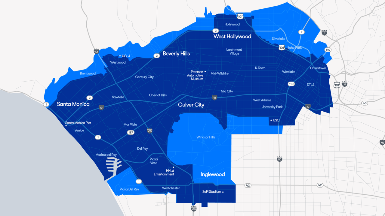
Riders in San Francisco now enjoy access to major neighboring hubs, including:
- Brisbane
- South San Francisco
- San Bruno
- Millbrae
- Burlingame
While this creates a contiguous, highly functional corridor stretching down the Bay Area peninsula, it maintains a curious boundary: it successfully skirts around San Francisco International Airport (SFO), keeping a deliberate safety and regulatory buffer to the west of U.S. Route 101.
Silicon Valley: Progress Toward Full Public Access
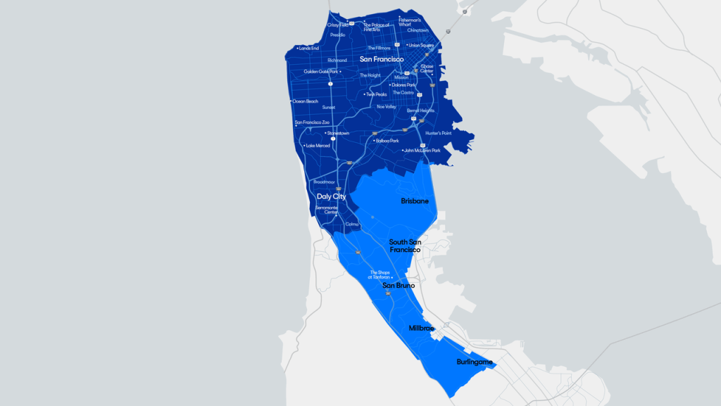
Just south of the San Francisco footprint lies Waymo’s Silicon Valley service area. Unlike its northern neighbor, this zone is relatively new—having only opened its virtual doors to the public a few months prior—and is not yet fully democratized for indiscriminate public ridership across its entire grid.
Despite these developmental limitations, the Silicon Valley zone expanded substantially to encompass:
- Menlo Park
- Deeper coverage within Palo Alto
Notably, while major commercial hubs are being integrated, the service area now encompasses the Palo Alto Airport—though this facility primarily serves private aviation and aviation enthusiasts rather than high-volume commercial air travelers.
Critically, despite their geographic proximity, Waymo’s San Francisco and Silicon Valley service areas remain disconnected. Passengers cannot currently hail a single autonomous vehicle to bridge the gap from one bay-adjacent zone to the other without transferring or stepping outside the active geofence.
Los Angeles: A Pan-Directional Growth Spurt
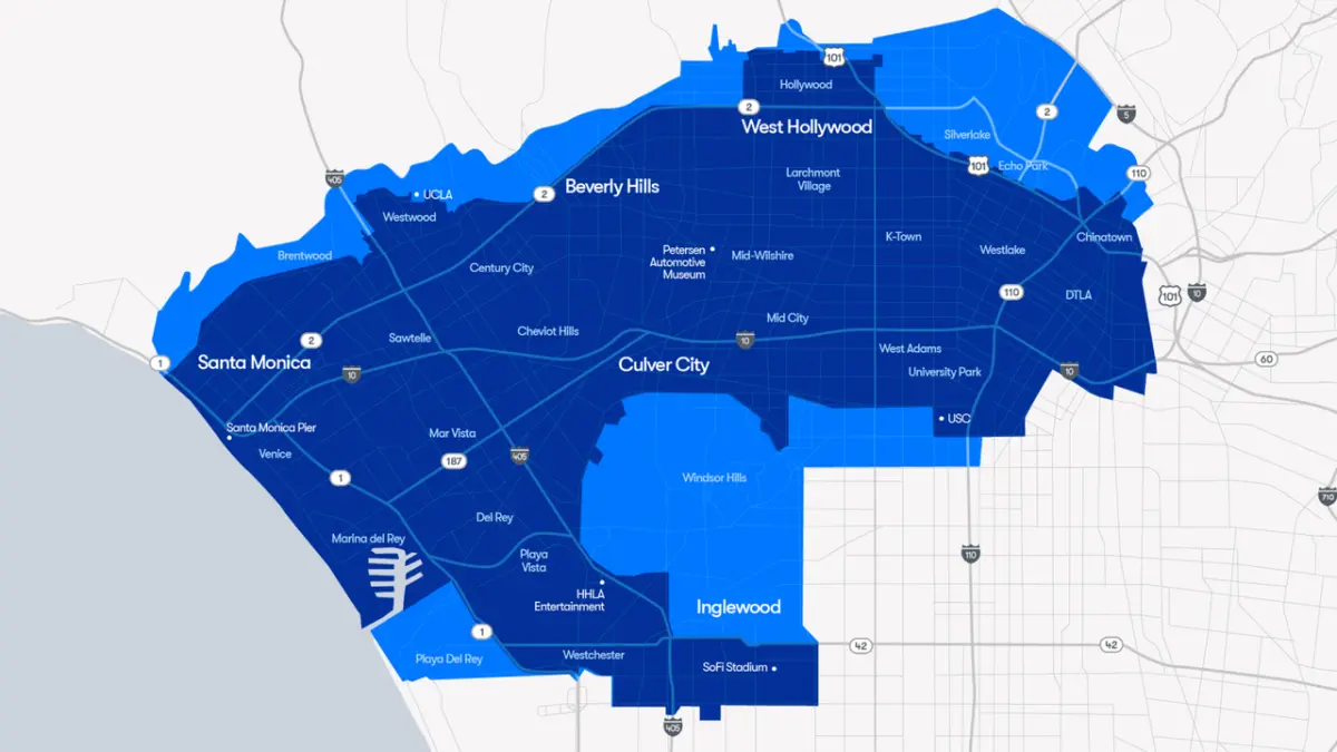
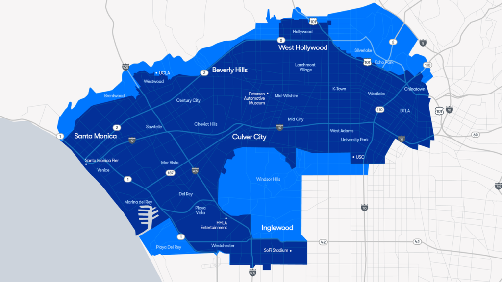
The expansion in the Greater Los Angeles area represents one of Waymo’s most complex urban scaling efforts to date. Going live incrementally over a 48-hour window, the LA expansion did not merely push outward in a single linear direction. Instead, it added dense, high-utility coverage across virtually every quadrant of the existing metropolitan zone.
The newly minted LA boundaries incorporate:
- Playa Del Rey
- Ladera Heights
- Echo Park
- Silver Lake
- Expanded swaths of Inglewood
- The entirety of the legendary Sunset Boulevard
Furthermore, the updated map integrates the University of California, Los Angeles (UCLA) campus for the very first time. While previous iterations brushed against the edges of Westwood right up to the campus border, students, faculty, and visitors can now utilize the service directly on-site.
This builds upon earlier 2025 expansions that connected major entertainment and transit hubs, such as the Howard Hughes Center, the Inglewood stadium complex, and The Forum. By absorbing these entertainment epicenters—along with strategic coverage near Dodger Stadium—Waymo has positioned its fleet as an ideal alternative for event-goers seeking to bypass nightmarish venue parking or avoid driving under the influence.
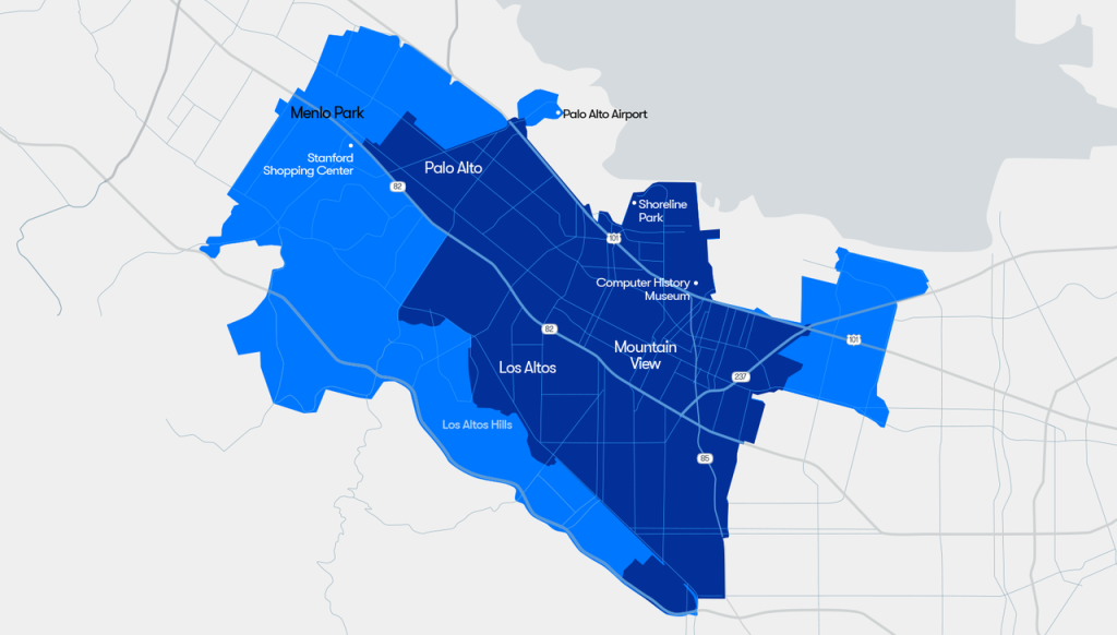
However, much like SFO in the north, LAX remains frustratingly out of reach. Waymo’s southern boundary pushes right up to the northern edge of Los Angeles International Airport, stopping just a few hundred yards short of the dedicated "LAX-it" ground-transportation and ride-hailing staging lot. While passengers may find drop-off points within a short walking distance—such as adjacent long-term parking structures—direct curb-to-terminal airport service in California remains an unfulfilled promise, contrasting with Waymo’s established airport operations at Phoenix Sky Harbor.
Supporting Context & Metrics: Infrastructure, Freeways, and Safety
Understanding the operational footprint of Waymo requires diving into the hard metrics and technological constraints that govern its fleet.
The Scale of the Footprint
With the addition of these 80+ square miles, Waymo’s total active operating territory in California now hovers near 250 square miles. This makes it one of the largest continuous and semi-continuous autonomous deployment zones globally. To achieve this, the company relies on a rigorous multi-stage rollout framework:
- Internal Validation: Months of physical mapping, sensor calibration, and software simulation.
- Employee-Only Testing: Restricted deployment where company personnel ride-test edge cases and chaotic urban anomalies.
- Limited Public Release: Gradual opening to waitlisted or localized civilian user bases.
- Full Public Availability: Unrestricted deployment to the general public via the Waymo One mobile application.
The Freeway Conundrum
One of the most notable technical limitations in Los Angeles is the current restriction against operating on high-speed freeways. While Waymo vehicles have cleared freeway testing hurdles for select riders in San Francisco, the LA fleet remains strictly bound to surface streets.
This presents a distinct logistical trade-off. For cross-town journeys during peak traffic hours, traversing LA’s tangled web of surface streets via Waymo can occasionally be slower than human-driven alternatives that utilize the freeway system. Nevertheless, autonomous freeway testing in Los Angeles is actively underway, and industry observers anticipate a public rollout of high-speed autonomous routing in the near future.
Comparative Analysis: Waymo vs. Tesla’s Imminent Robotaxi Debut
As Waymo cements its physical presence across California, the broader autonomous vehicle industry is fixated on Austin, Texas, where Tesla has tentatively slated the launch of its long-awaited robotaxi service. The clash between these two companies highlights diametrically opposed engineering philosophies, safety validation standards, and regulatory frameworks.
Engineering Approaches: Surface Streets vs. Highways
Waymo’s architecture relies heavily on a redundant sensor suite combining LiDAR, radar, cameras, and ultra-high-definition pre-mapped three-dimensional geofences. This system allows Waymo to tackle the most chaotic, unpredictable urban environments first—such as dense pedestrian zones in San Francisco, chaotic nightlife districts in Austin, and complex multi-modal traffic in Los Angeles.
Tesla, conversely, has historically pursued a camera-only, vision-based neural network approach. Interestingly, Tesla’s consumer-facing Level 2 driver-assist software (Autopilot and Full Self-Driving) debuted on controlled-access highways—an environment that, while operating at high speeds, presents far fewer unpredictable variables than pedestrian-heavy surface streets. Highways feature clear lane markings, unidirectional traffic flows, and an absolute absence of cross-traffic and unpredictable non-motorized road users.
Automation Levels Explained (SAE J3016)
To understand the gulf between the two systems, it is vital to examine the Society of Automotive Engineers (SAE) definitions of driving automation:
- Level 2 (Partial Automation): The vehicle can control steering, acceleration, and braking under specific conditions, but a human driver must remain fully engaged, monitor the environment continuously, and take immediate control if necessary. Both Tesla’s current Autopilot and FSD suites operate strictly at Level 2.
- Level 4 (High Automation): The vehicle can perform all driving tasks and monitor the environment autonomously without human intervention, but only within specific operational design domains (ODDs)—such as geofenced urban centers. Waymo’s driverless taxis operate entirely at Level 4.
If Tesla successfully launches its driverless commercial ride-hailing fleet in Austin without safety drivers, that specific deployment would technically cross into Level 4 territory—provided it does not rely heavily on continuous, off-site teleoperation to steer vehicles through complex edge cases.

The Battle of Timelines and Validation Standards
For over a decade, Tesla CEO Elon Musk has repeatedly promised that fully autonomous, driverless Teslas were perpetually "next year," continually moving the deployment goalposts. The announcement of an Austin robotaxi launch following what reports indicate were merely "several days" of unsupervised testing stands in stark contrast to Waymo’s rigorous, multi-year validation playbook.
While Waymo spends years securing regulatory permits from bodies like the California Public Utilities Commission (CPUC) and the Department of Motor Vehicles (DMV), Tesla’s rapid-deployment strategy has raised serious questions among transit safety advocates regarding oversight, accountability, and public trust.
Future Outlook
The coming weeks will serve as a critical crucible for the autonomous vehicle industry. As Waymo integrates its massive 80-square-mile expansion across California—bringing iconic locales like UCLA, Sunset Boulevard, and the San Francisco Peninsula firmly into its automated ecosystem—all eyes will shift to Austin, Texas.
Whether Tesla’s impending June launch marks a genuine turning point in commercial autonomy or simply another iterative step in its long-running driver-assist journey remains to be seen. What is clear, however, is that the era of autonomous public transit is no longer a distant sci-fi projection; it is a sprawling, highly competitive reality reshaping the very fabric of American metropolitan infrastructure. As Waymo accelerates its geographic footprint and refines its freeway algorithms, the pressure on competitors to deliver safe, verifiable, and scalable driverless operations has never been higher.
