

Executive Overview
In the high-stakes theater of Arctic exploration and climate monitoring, a quiet revolution is taking shape on the razor-sharp edge of robotics and environmental science. A team of visionary roboticists in Canada has successfully engineered a drone capable of doing what was previously thought impossible for aerial robotics: landing, latching, and perching autonomously on the steep, glassy, and deeply treacherous slopes of icebergs and glaciers.
Dubbed the Ice Dart, this specialized unmanned aerial vehicle (UAV) utilizes a groundbreaking bio-inspired microspine landing gear system. Drawing direct inspiration from the predatory mechanics of feline claws, the Ice Dart can scale and anchor itself onto vertical ice formations angled at nearly 60 degrees. It achieves this remarkable feat in sub-zero temperatures and amid howling Arctic winds gusting up to 30 kilometers per hour.
Published in IEEE Transactions on Field Robotics, this milestone represents a paradigm shift in how scientists approach remote sensing in Earth’s most punishing environments. For decades, the utility of drones in polar regions has been fundamentally hamstrung by a glaring physical limitation: battery capacity. Hovering against persistent winds drains a drone’s power reserves within minutes, forcing a swift return to a ship or basecamp. By introducing a reliable perching mechanism, the Ice Dart transforms from a fleeting aerial observer into a stationary, long-term environmental sentinel.
Once secured to an iceberg, the drone can power down its main flight systems, dramatically dropping its energy consumption, eliminating its thermal and radio-frequency signatures, and remaining virtually silent on the ice for days or even months at a time. This capability bridges a critical data gap between high-altitude satellite observation and short-duration aerial flyovers, offering unprecedented insights into glacial mechanics, iceberg trajectories, and the catastrophic structural failures that precede ice calving. As human activity intensifies in the Arctic—driven by receding ice sheets and opening shipping lanes—the Ice Dart stands ready to redefine polar surveillance, offering a glimpse into a future where autonomous machines keep watch over a rapidly warming planet.
Detailed Chronology: From Concept to Icelandic Glaciers
The journey of the Ice Dart from a theoretical computer-aided design model to a field-tested polar robot is a testament to iterative engineering. The research team, anchored at the Université de Sherbrooke in Quebec, has spent years solving the complex dynamics of robotic perching. Their pedigree includes developing autonomous drones capable of landing on fast-moving commercial trucks, trailers, boats, and steep, angled roofs. However, transitioning from man-made asphalt and timber to the hyper-variable, hyper-slippery medium of glacial ice presented an entirely new echelon of physical challenges.
The Engineering Breakthrough
The foundational hurdle of landing on ice is twofold: kinetic energy dissipation and surface penetration. When a 2.65-kilogram drone strikes a rigid, vertical ice sheet at three meters per second, the kinetic energy must be absorbed instantaneously without bouncing the aircraft off the surface or shattering its airframe.
To solve this, the Sherbrooke team utilized a carbon-fiber framework structured around four X-shaped legs connected to the central body via sophisticated pivot joints. Embedded within this landing gear is a friction shock-absorber mechanism comprised of 38 distinct disks. As the drone makes contact and its legs compress vertically upon impact, these disks generate controlled friction torque. This ingenious mechanical action deliberately lowers the UAV’s center of mass, safely dispersing the kinetic energy of the landing while guiding the landing gear into its deployed configuration.
The Bio-Inspired Claws
Once the kinetic energy is managed, the drone must secure its footing before gravity and wind can peel it away from the slope. The solution came from observing the natural world.
"The inspiration for the retractable spines in the feet came from looking at a cat’s claws and their ability to deploy only when needed," explains Isaac Tunney, a postdoctoral researcher in mechanical and robotics engineering at the Université de Sherbrooke and lead author of the study. "I wanted to create feet that would naturally and passively engage their spines in the ice at the right moment, regardless of the drone’s orientation, the surface geometry, or the ice conditions."
Each of the Ice Dart’s four feet is equipped with two retractable microspines—one optimized for uphill traction and one for downhill security. The mechanics are entirely passive:
- The Downhill Foot: Bears the heaviest initial load during impact, triggering a larger, sturdier spine to bite deep into the ice matrix.
- The Uphill Foot: Operates under much lower loads on steep inclines, utilizing a thinner, more sensitive spine that engages effortlessly under minimal pressure.
Crucially, these spines remain safely tucked away during flight and only emerge as the landing suspension compresses. This prevents premature wear and tear while ensuring that grip is achieved instantaneously upon impact.
Field Trials in Iceland
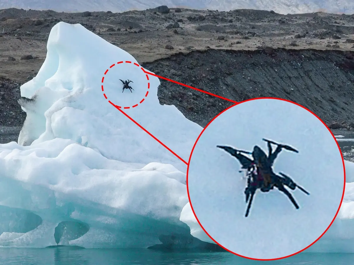
Following exhaustive laboratory simulations, the research team packed their gear for the ruggedly breathtaking terrain of the Fjallsjökull glacier in southeast Iceland. Pronounced FYATLS-yuh-kuutl, this dramatic glacier empties into a frigid lagoon choked with floating icebergs, offering a natural laboratory that mirrors the harsh operating conditions of the high Arctic.
During the field tests, the Ice Dart faced persistent winds, shifting air temperatures hovering between 0 and 10 degrees Celsius, and volatile surface conditions. Despite these hurdles, the drone performed flawlessly. It successfully executed perching maneuvers at approach speeds of up to 3 meters per second on icy slopes reaching an astonishing 58 degrees. Most impressively, the Ice Dart achieved a 100 percent success rate, maintaining its grip even when buffeted by crosswinds reaching 30 kilometers per hour.
Supporting Context & Metrics: The Physics of Polar Perching
To understand the magnitude of the Ice Dart’s success, one must examine the specific metrics and engineering specifications that govern its design, operational capacity, and environmental utility.
Technical Specifications Matrix
| Metric Category | Specification / Value | Operational Significance |
|---|---|---|
| Total Weight | 2.65 kilograms | Lightweight carbon-fiber construction ensures high payload-to-weight ratio for sensor integration. |
| Airframe Geometry | Quadcopter layout with 4 X-shaped legs | Provides multi-axis stability during flight and a wide footprint for stable landing angles. |
| Impact Absorption | 38-disk friction shock-absorber | Generates friction torque to lower center of mass and dissipate kinetic energy safely. |
| Grip Mechanism | Dual retractable microspines per foot | Passive deployment; one uphill and one downhill spine ensure anchor reliability under varied loads. |
| Maximum Slope Angle | Up to 58 degrees | Allows the drone to land on vertical and near-vertical glacial cliffs and iceberg faces. |
| Approach Velocity | Up to 3 meters per second | High-tolerance landing speed minimizes flight-control complexity in turbulent air. |
| Wind Resistance | Fully operational up to 30 km/h | Maintains a 100% perching success rate in gusty, adverse weather conditions. |
| Power State (Perched) | Main systems offline (silent) | Drastically reduces energy draw, thermal signature, and RF output for extended deployment. |
Why Icebergs Matter: The Limitations of Current Surveillance
Icebergs are notoriously dynamic, dangerous, and difficult to monitor. As they drift away from polar ice shelves into open ocean currents, they begin to melt, fracture, and roll over without warning. Traditional methods of tracking and studying them suffer from major logistical drawbacks:
- Helicopter Deployments: Expensive, risky for human pilots in unpredictable weather, and carbon-intensive.
- Dropped Instruments & Darts: Often lack mobility, offering stationary data points that cannot adapt to changing environmental conditions.
- Satellite and Ship Radar: Excellent for macro-level detection and positioning, but incapable of gathering micro-level physical data—such as internal ice stress, local thermal gradients, and surface meltwater dynamics.
By deploying an autonomous drone that can physically latch onto an iceberg and remain there for extended periods, researchers gain a persistent, on-site monitoring platform. The drone can house meteorological sensors, cameras, and GPS modules, turning a floating chunk of glacial ice into a smart, data-transmitting beacon.
Official Statements and Expert Perspectives
The broader scientific community has taken note of the Ice Dart’s debut, viewing the technology not merely as an engineering novelty, but as a potential turning point for cryospheric research.
The Power of Stationary Observation
Professor Alexis Lussier Desbiens, a co-author of the study from the Université de Sherbrooke, emphasizes how perching changes the fundamental economics of robotic field operations:
"The ability to land rather than hover can fundamentally change how drones are used in the field. Once a drone has landed, energy consumption drops dramatically, allowing much longer observation periods with a small aircraft. The drone also becomes completely silent and can even reduce or eliminate its thermal and RF signature by shutting down major onboard systems."
This silent operational profile opens up secondary applications in wildlife monitoring, environmental surveillance, and remote sensing where minimizing human or machine disturbance is paramount.
External Validation and Glacial Mechanics
William D. Harcourt, a researcher at the University of Aberdeen in Scotland who specializes in Arctic glaciers, snow, sea ice, and machine-learning applications in remote sensing, was not involved in the study. However, he sees profound implications for glaciology:
"Near the front of tidewater glaciers, these systems could enable measurement of stress and strain and help us understand calving processes. Drones can be used as a mobile GPS, literally acting as a receiver on the ice, but the system would need to solve tilting issues as 3D change measurements usually required the antenna to be horizontal. However, if these problems can be solved, it could be used to track iceberg movements."
Harcourt’s insights point directly to the complex physical dynamics of ice sheets. Tidewater glaciers—where massive rivers of ice meet the ocean—are prime locations for iceberg calving. Understanding the pre-failure stress fractures in these ice walls could vastly improve predictive models for sea-level rise and coastal hazards. If robotic perching drones can anchor themselves near these fracture zones and monitor micro-deformations over weeks, scientists can gain unprecedented early-warning data regarding ice sheet instability.
Future Outlook: The Road to the Canadian Arctic
While the successful tests on the Fjallsjökull glacier in Iceland represent a monumental proof-of-concept, the development team at the Université de Sherbrooke is far from finished. The transition from controlled academic testing to operational deployment in the wild requires overcoming several remaining engineering milestones.
Upcoming Milestones and Arctic Deployments
The immediate roadmap for the Ice Dart includes two critical technological advancements:
- Autonomous Landing Site Selection: Equipping the drone with advanced onboard computer vision and machine-learning algorithms that allow it to scan a chaotic, shifting iceberg surface in real-time and autonomously select the safest, most structurally sound landing spot without human teleoperation.
- Emergency Take-off Capabilities: Designing fail-safes for situations where the host iceberg undergoes a catastrophic structural failure, such as rolling over or splitting apart. The drone must be capable of rapidly disengaging its microspines, firing up its rotors, and executing an emergency launch from a tumbling surface.
The ultimate proving ground is fast approaching. This coming August, the Ice Dart will be deployed on a high-stakes Canadian Arctic mission. During this expedition, the drones will be launched from research vessels to actively land on remote Arctic icebergs, collect multi-day environmental datasets, and serve as ground-truth validators for ship-based iceberg-detection radar systems.
As industrial traffic, resource exploration, and tourism expand into previously impassable northern waters, the safety of maritime navigation depends heavily on accurate iceberg tracking. By bridging the gap between aerial agility and terrestrial stability, the Ice Dart proves that the future of Arctic exploration lies not in flying higher or faster, but in knowing when—and how—to plant our feet on the shifting ice.
