

Executive Overview
For decades, the exploration and industrial development of the world’s oceans have faced a persistent, frustrating bottleneck: visibility. When remotely operated vehicles (ROVs) and autonomous underwater vehicles (AUVs) descend to the seafloor, their operations are routinely compromised by environmental disturbances. Whether an ROV’s thrusters are kicking up clouds of fine marine sediment, or a submersible is operating in naturally turbid estuarine waters, onboard optical cameras are frequently blinded.
Conventionally, the protocol for handling these blinding sediment plumes has been passive and costly: wait. Operators must halt all delicate maneuvers, hover in place, and idle millions of dollars’ worth of deep-sea hardware while gravity slowly pulls suspended particles back to the benthic floor. This operational downtime costs marine industries, research institutions, and defense agencies countless hours and millions of dollars annually.
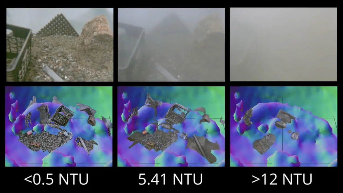
Enter a transformative technological breakthrough developed by researchers at the Woods Hole Oceanographic Institution (WHOI). Amy Phung (SM ’23, PhD ’26) and her advisor, Senior Scientist Richard Camilli (SM ’00, PhD ’03), have engineered a real-time navigation and imaging system that fundamentally bypasses the limitations of underwater optical vision. By synergizing acoustic sonar mapping with an advanced image-matching algorithm originally pioneered in France, their system allows submersibles to "see" and navigate through impenetrable clouds of sediment in real time.
This development bridges a historical gap in marine robotics: the trade-off between the high-resolution, low-penetration capabilities of optical cameras and the low-resolution, high-penetration capabilities of acoustic sonar. By fusing these two modalities through high-speed computational processing, Phung and Camilli have created a robust methodology that enables submersibles to map, approach, and interact with objects of interest in zero-visibility conditions.
The implications of this breakthrough stretch far beyond academic oceanography. From the delicate assembly and maintenance of deep-sea renewable energy infrastructure to hazardous military operations involving unexploded ordnance (UXO), this new system promises to redefine what robotic systems can achieve beneath the waves. As humanity increasingly turns to the oceans for resources, infrastructure, and security, technologies that conquer the murk of the deep sea will form the bedrock of the blue economy.
Detailed Chronology: From Seafloor Frustration to Algorithmic Triumph
The genesis of this breakthrough is rooted in the daily realities of field robotics and the relentless pursuit of efficiency in extreme environments. To understand the significance of Phung and Camilli’s work, one must trace the timeline of underwater computer vision and the persistent hurdles that have plagued marine engineers for half a century.
The Historical Bottleneck of Subsea Vision
Since the inception of modern oceanography in the mid-20th century, marine scientists and engineers have struggled against the physical properties of water. Unlike air, water absorbs and scatters light rapidly. Beyond a few tens of meters—even in the clearest tropical waters—ambient sunlight vanishes entirely, forcing submersibles to rely on artificial lighting. However, artificial light interacting with suspended particulate matter creates backscatter, a phenomenon akin to driving a car through a heavy snowstorm with the high beams on.
When ROVs settle on soft sediment seabeds—composed of silts, clays, and organic detritus—the interaction of vehicle thrusters with the benthic boundary layer instantly generates dense plumes of turbidity. For decades, the robotics industry accepted this as an unavoidable operational tax. Operators monitored muddy gray screens, waiting minutes or even hours for the water column to clear before executing tasks such as valve manipulation, core sampling, or archaeological recovery.
The WHOI Initiative: Framing the Problem
When Amy Phung began her graduate studies at WHOI under the guidance of Richard Camilli, the limitation was clear. Camilli, an expert in marine robotics, extreme environments, and in-situ sensing, recognized that traditional computer vision approaches—which rely heavily on pristine visual data and high frame-rate RGB imagery—were fundamentally unsuited for the realities of benthic intervention.
Phung and Camilli initiated a project to rethink how underwater vehicles construct spatial awareness. They hypothesized that while optical cameras were rendered useless by turbidity, acoustic sensors—specifically multibeam and imaging sonars—remained entirely indifferent to suspended sediment particles. Sound waves propagate efficiently through particulate-laden water, bouncing off solid surfaces regardless of optical clarity.
However, sonar systems traditionally suffered from a critical drawback: resolution. While a high-definition camera can delineate the texture of a bolt or the serial number on a subsurface assembly, standard sonar imagery is often grainy, plagued by acoustic multipath interference, and difficult for automated systems to interpret quickly.
The Convergence of Sonar and Edge-AI
The breakthrough occurred when the WHOI team addressed the computational bottleneck of real-time sonar processing. Historically, converting raw acoustic returns into actionable, high-density spatial maps required immense computing power, introducing latency that made real-time closed-loop robotic control impossible.
To solve this, Phung and Camilli integrated acoustic mapping hardware with a cutting-edge image-matching algorithm. Originally developed by computer vision researchers in France for aerial and terrestrial applications, this algorithm was adapted by the WHOI team to estimate the relative depth of each pixel in a two-dimensional scene instantaneously.
By combining the all-weather, turbidity-proof nature of sonar with this rapid depth-estimation framework, Phung created a pipeline capable of processing acoustic data on the fly. The vehicle no longer needed to wait for the water to clear; instead, it could construct a live, spatial model of its immediate surroundings using acoustic reflections, instantly translating low-resolution sonar data into a navigable, high-confidence geometric map.
Supporting Context & Metrics: Navigating the Benthic Realm
To appreciate the engineering triumph achieved by the WHOI team, one must examine the operational parameters, physical constraints, and technological metrics that govern deep-sea robotics.
The Physics of Benthic Turbidity
The benthic zone—the ecological region at the very bottom of a body of water—is characterized by soft sediment deposits. When a remotely operated vehicle weighing several tons positions itself near the seafloor, its vertical and horizontal thrusters displace thousands of liters of water per minute. This hydrodynamic disturbance lifts fine-grained sediments into suspension.
| Environmental Variable | Optical Camera Performance | Acoustic Sonar Performance | WHOI Integrated System |
|---|---|---|---|
| Clear Water | Excellent (High Detail) | Moderate (Low Detail) | Superior (Fused Data) |
| Turbid Water / Mud | Zero (Blinded by Backscatter) | High (Unaffected by Particles) | High (Real-Time Mapping) |
| Processing Latency | Low to Moderate | High (Historically) | Real-Time (Optimized) |
| Spatial Awareness | Limited Field of View | 360-Degree/Wide Sector | Comprehensive 3D Model |
As detailed in the table above, while traditional systems are forced to choose between the high fidelity of optical sensors and the resilience of acoustic sensors, the WHOI framework synthesizes both. The system uses acoustic data to navigate through the turbidity cloud safely, closing the distance to the target until the vehicle is close enough for optical cameras to pierce the remaining millimeters of water and capture high-resolution imagery.
The "China Shop in the Dark" Analogy
To articulate the function of this technology, Richard Camilli offered a vivid and intuitive metaphor:
"An analogy would be if you were to go into a china shop in the dark, and try to pick your way around to find a specific coffee mug without knocking things over. This would allow you to do that."
In the context of the deep sea, the "china shop" represents fragile marine ecosystems, expensive subsea infrastructure (such as subsea wellheads, risers, and manifolds), or unstable unexploded ordnance. The "darkness" represents the impenetrable turbidity clouds stirred up by the vehicle itself. The "coffee mug" is the specific object of interest—be it a scientific sensor package, a structural bolt, or a military mine.
Without Phung and Camilli’s system, an ROV navigating this "china shop" in a cloud of sediment is essentially operating blind, risking catastrophic collisions with multi-million-dollar infrastructure or triggering dangerous devices. With the new system, the vehicle maintains a continuous, acoustic spatial awareness of every obstacle in the room, allowing it to navigate with millimeter-class precision despite zero visibility.
Official Statements and Expert Insights
The development of this technology represents a significant leap forward in marine robotics, drawing praise and analytical commentary from the oceanographic community.
Insights from the Inventors
Reflecting on the collaborative nature of the research, Amy Phung and Richard Camilli emphasized the interdisciplinary approach required to bridge acoustic sensing and advanced computer vision.
"We are essentially teaching robots to ‘feel’ their way through space using sound in the same way human eyes process light and shadow," explains Phung. "By optimizing the computational pipeline, we’ve removed the lag that previously made real-time acoustic mapping impossible for small-form-factor submersibles."
Richard Camilli underscored the operational shift this technology introduces to marine industries. For decades, subsea operations have been dictated by environmental constraints. "When you are operating at depths of thousands of meters, time is measured in thousands of dollars per hour," Camilli notes. "Eliminating the waiting period—the time spent idling while sediment clouds settle—changes the economic equation of offshore work entirely."
Industry Implications and Expert Consensus
Independent marine roboticists have noted that the integration of French image-matching algorithms with acoustic sensor streams marks a maturing of edge-computing capabilities in extreme environments. As processing power aboard submersibles increases, algorithms that were once confined to land-based server farms can now run locally on ROV and AUV payloads.
Defense analysts specializing in naval warfare and mine countermeasures have similarly highlighted the value of the technology. Handling subsea munitions requires absolute precision and zero margin for error. The ability to approach an unexploded mine through a cloud of seabed silt without losing spatial orientation significantly reduces risk to personnel and equipment.
Future Outlook: Transforming Marine Industries and Exploration
As Amy Phung progresses toward the completion of her doctoral research at WHOI and Richard Camilli continues to spearhead innovations in extreme-environment robotics, the horizon for this technology is expanding rapidly. The transition from laboratory validation to commercial and scientific deployment is poised to impact four major sectors:
1. Scientific Exploration and Marine Archaeology
In delicate marine environments, such as deep-sea hydrothermal vents, cold seeps, and fragile coral gardens, minimizing physical disturbance is paramount. Furthermore, marine archaeologists mapping delicate shipwrecks often face sites buried under centuries of silt. The WHOI system will allow robotic explorers to map and interact with these sensitive sites without causing destructive silt-outs that obscure artifacts for hours at a time.
2. Offshore Renewable Energy and Subsea Infrastructure
The global push toward offshore wind energy and deep-water resource management requires unprecedented levels of subsea construction and inspection. Subsea cables, floating turbine anchors, and manifold systems require regular maintenance. By enabling ROVs to work continuously through self-generated turbidity, this technology will dramatically accelerate construction timelines and reduce operation and maintenance (O&M) expenditures for offshore energy operators.
3. Defense and National Security: Unexploded Ordnance (UXO)
Naval defense operations frequently involve the detection, identification, and neutralization of historic and modern naval mines. These devices are often resting on soft seabeds where any approach generates immediate, blinding sediment clouds. Equipping military ROVs and autonomous mine-hunting systems with the WHOI acoustic-visual mapping framework will enhance the safety and success rate of explosive ordnance disposal (EOD) teams globally.
4. Autonomous Underwater Vehicles (AUVs)
While ROVs are tethered and continuously monitored by human operators, the holy grail of marine robotics is full autonomy—deploying AUVs that can operate independently for weeks or months without human intervention. By providing AUVs with the ability to dynamically map and navigate through zero-visibility environments, Phung and Camilli’s work removes a major stumbling block on the path toward truly autonomous benthic intervention.
Conclusion
The depths of the ocean have long shielded their secrets behind opaque barriers of distance, pressure, and turbidity. While humanity has mapped the surface of Mars with greater precision than the floor of our own ocean, technologies like the one developed at the Woods Hole Oceanographic Institution are steadily chipping away at the unknown. By turning sound into sight and transforming an operational liability into a managed variable, Amy Phung and Richard Camilli have opened a clear window into the murkiest corners of our blue planet.
